In development · not in the app stores yet

Find a road for the ride, not just the arrival.

Motoyla is a mobile app for motorcyclists in Turkey. It brings together finding a road worth riding, planning it for your motorcycle, turn-by-turn navigation, recording your ride privately and, if you want, sharing it as a route.

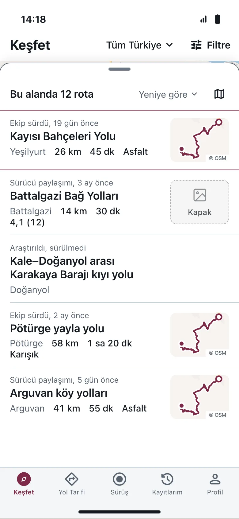
Discover screen in Turkish: a list of routes in the area, each row with a source label, route name, length and time.
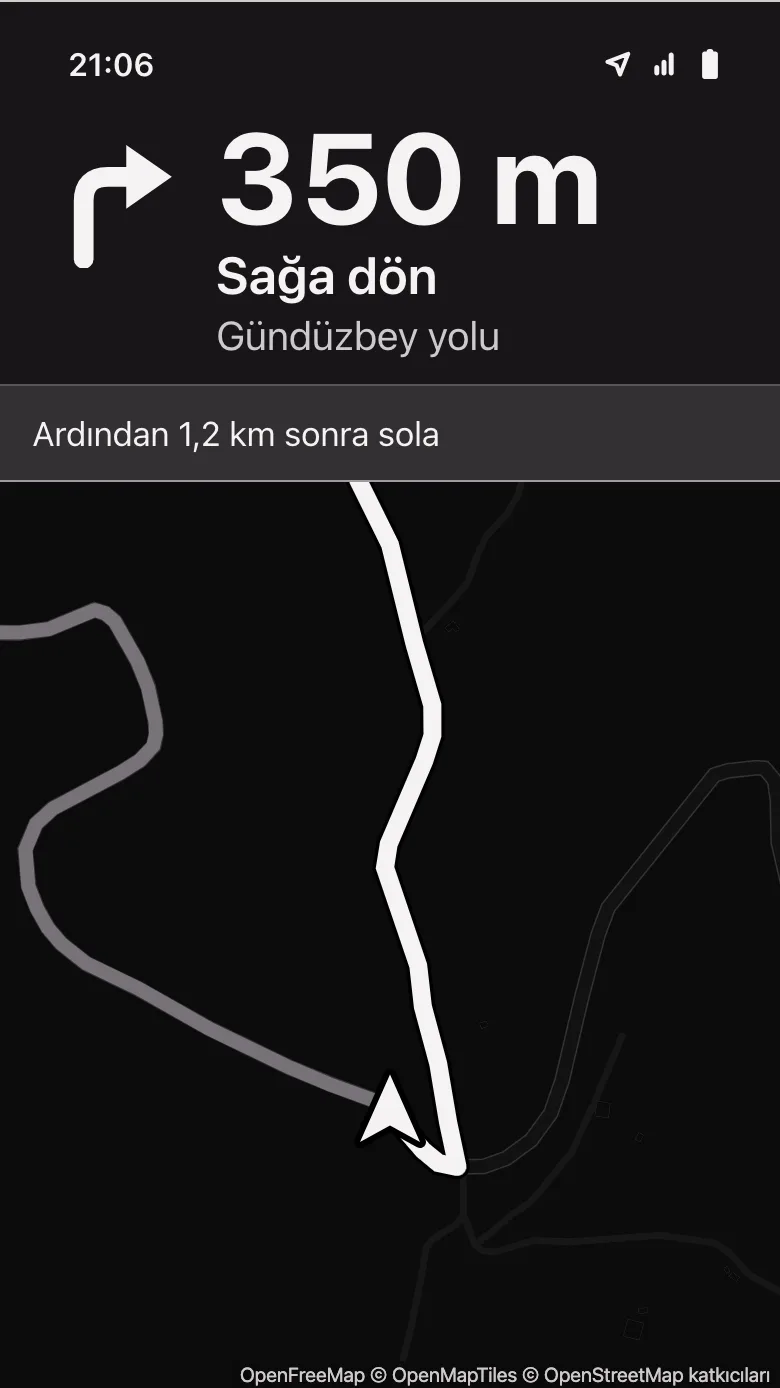
Navigation screen in the night theme, in Turkish: turn right in 350 metres, with the road ahead on the map.
From the app design · sample data, Turkish interface

The problem

General navigation is built around arriving. For a rider, the road itself matters.

  • Where can I ride today?
  • Where are the twisty roads worth riding near me?
  • Does this road suit my motorcycle?
  • Has this shared route actually been ridden?

Who it is for

First, leisure and weekend riders who look for a route in their free time and care more about the ride than the destination. Touring riders planning longer trips, and scooter and moped riders, use the same core flow.

Why we start in Turkey

Route knowledge today is scattered across forums, social media posts and personal GPX files. Who rode it, when, and what the road is like now is often unclear. Motoyla aims to present that knowledge in Turkish, in a structured form, with a clear source.

Product

Discover, plan, ride, record, share.

Every step below is in the scope of the first release (MVP) and is in development now. The screens come from the approved app design, which is in Turkish; the routes and numbers in them are sample data.

01

Discover a road worth riding

See motorcycle routes in your region on a map and in a list. Each route clearly shows its length, estimated time, road type and source.

  • You can browse the route map and details without signing in.
  • A source label says who produced the information: ridden by the team, shared by a rider, or researched but not ridden.
  • No label claims that a road is safe.
In MVP scope · in development
Route list in Turkish: routes labelled ridden by the team, shared by a rider, and researched but not ridden, with length, time and road type.
From the app design · sample data

02

Plan for your motorcycle

Search for a place or pick one on the map. The route is calculated with a motorcycle or scooter and moped profile instead of a car profile.

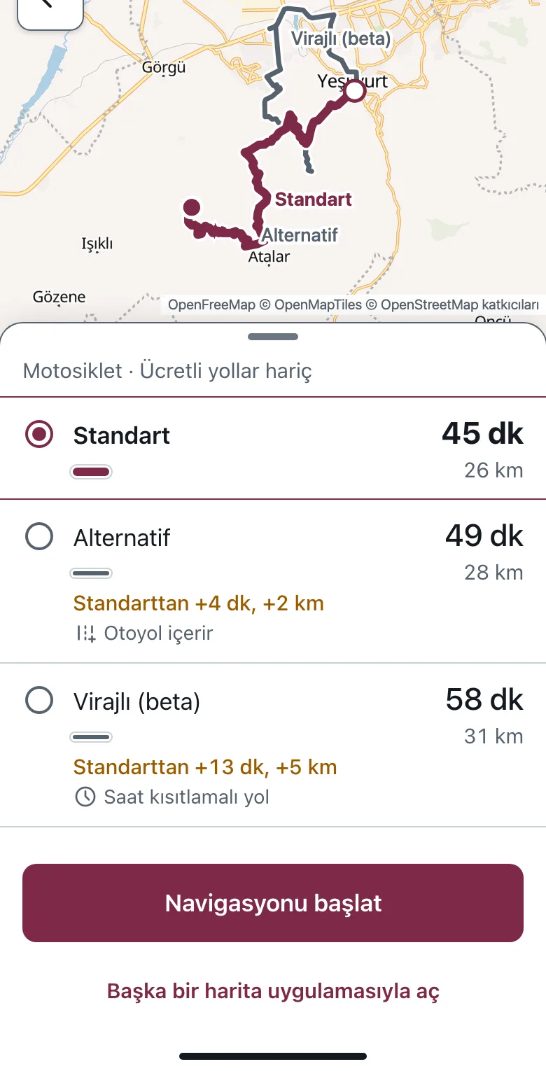
  • Compare the standard route with alternatives by time and distance.
  • The twisty option is labelled Virajlı (beta) and stays in beta until it is validated in the field.
  • Avoid tolls, ferries and unpaved roads, as far as the routing service supports it.
In MVP scope · in development
Route comparison screen in Turkish: standard 45 minutes 26 km, alternative 49 minutes 28 km, Virajlı (beta) 58 minutes 31 km, and a start navigation button.
From the app design · sample data

03

Ride it turn by turn

A riding screen you can read at a glance with the phone mounted on the bike: the next manoeuvre, its distance, the distance left and the arrival time.

  • If you leave the route, a new path is calculated that brings you back to the route you chose.
  • When GPS gets weak or the connection drops, the screen says so plainly.
  • Spoken guidance is optional and starts off on every ride.
In MVP scope · in development
Navigation screen in the night theme, in Turkish: turn right in 350 metres, then left after 1.2 km.
From the app design · sample data

04

Record your ride privately

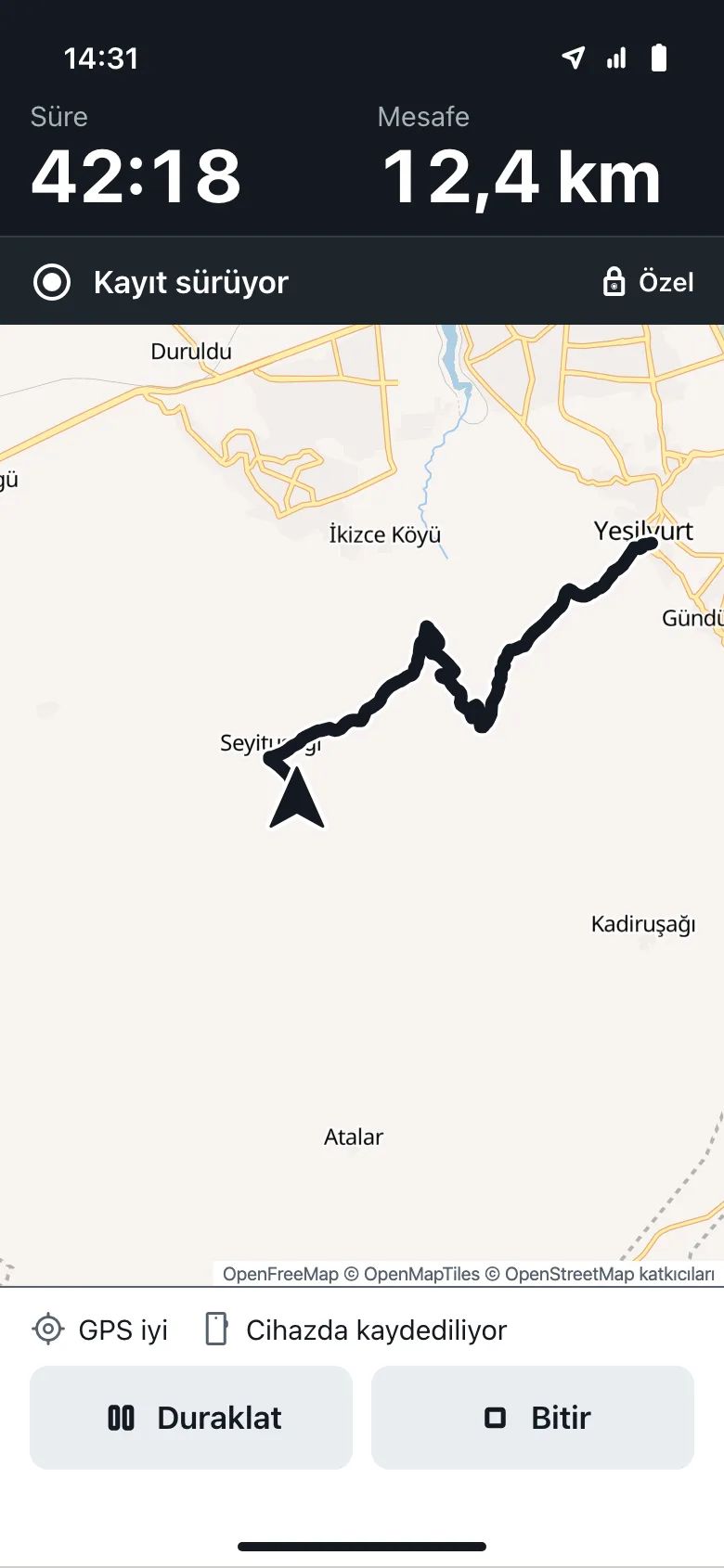
Recording carries on on your device without an internet connection. Your rides are visible only to you; no ride ever becomes public on its own.

  • Recording needs an account; navigation does not.
  • If the app closes, an unfinished ride can be recovered.
  • When GPS drops out, the gap is not bridged with a straight line and counted as the real road.
In MVP scope · in development
Ride recording screen in Turkish: time 42:18, distance 12.4 km, recording and private status, pause and finish buttons.
From the app design · sample data

05

Share it as a route, if you want

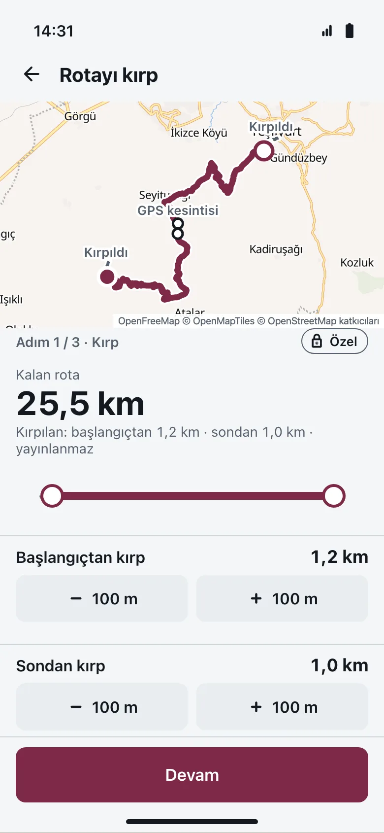
You create a public route that is separate from your private ride. Trim the start and end, add a title and tags, and see exactly what will be shared before you publish.

  • Trimmed start and end sections are not published.
  • Your ride times, speed and raw GPS track are not shared.
  • Publishing takes an explicit confirmation, and you can unpublish the route later.
In MVP scope · in development
Trim route screen in Turkish: 25.5 km left, 1.2 km trimmed from the start and 1.0 km from the end, a private label and a continue button.
From the app design · sample data

Planned for the MVP · not built yet

Natural-language route discovery with Claude

Say what you want, find the right route in the catalogue.

Filters work well, but riders describe what they want in sentences. In the feature we are planning, Claude will turn your sentence into structured preferences and recommend only routes that already exist in the catalogue. It will not draw new roads.

What the rider types (in Turkish)

“Hafta sonu için kısa, asfalt ağırlıklı, çok virajlı olmayan bir sürüş istiyorum.”

Preferences Claude would extract

When
Weekend
Length
Short
Surface
Mostly paved
Curves
Few to moderate

The query means: “I want a short, mostly paved ride for the weekend that is not too twisty.” This is an example of the planned flow, not a working demo.

  1. 1

    Understand preferences

    Claude maps only the preferences you actually stated into fields. If something is unclear, it asks a short question.

  2. 2

    Fetch candidates

    Our server queries the existing route catalogue with those fields and selects candidate routes.

  3. 3

    Recommend with reasons

    Claude recommends existing route ids from those candidates only, explaining why with their verified data.

  4. 4

    Back to the normal flow

    You open the recommended route's details, plan it and start navigation as usual.

Limits

  • No invented roads. Claude does not generate road geometry or a new rideable route.
  • No claim without data. Safety, road surface condition, scenery or freshness are not stated unless the data says so.
  • The server checks. Recommended route ids, access rights and returned fields are validated on the server.

Privacy and cost

  • Opt-in. The feature runs only when you start it, with usage quotas and a cost ceiling.
  • No raw location. In the first scope, no GPS track or ride history is sent to Claude.
  • Key stays on the server. The API key lives on the server, not in the app. If anything fails, normal discovery and filters keep working.

Project

One developer, working with AI agents.

Emre Dağ, founder

Motoyla is a project founded by Emre Dağ and built solo with AI agents in Claude Code. The plan is to bring more people in as the scope grows.

The app interface was designed with Claude Design: light and dark themes, Turkish interface copy, accessibility and map attribution rules, all in one approved design baseline.

Before any code is written, each piece of work is planned with a task list, acceptance criteria and an evidence record. Technical risks are tested first with small, disposable spikes.

  • Open map and routing spikesA MapLibre and OpenFreeMap map on iOS and Android; a local Valhalla routing graph built from Turkey's OpenStreetMap data.
  • Motorcycle and scooter routing profilesA 20-route test set; comparative route output with motorcycle and 50 cc scooter profiles.
  • Virajlı (beta) ranker and navigation prototypeA prototype that ranks route alternatives, and a navigation controller prototype written in Flutter.
  • First device trialsRide recording trials in the background on an iPhone 13 and with a foreground service on a Galaxy M21.
  • Legal preparation and content sourcesA legal review brief covering location data, licences and user content; an editorial template that records source, licence and attribution for route content.

Not done yet: end-to-end validation on a real field ride, the app itself and a store release. So today there are no users, no revenue and no downloads.
Contact

Write to us with questions, collaboration ideas or feedback.

[email protected]